
Understanding Property Boundary Dispute Legal Solution in Nepal
Property boundary disputes are resolved through established legal frameworks in Nepal. Property boundary dispute legal solution is sought by thousands of Nepalese landowners annually. These conflicts arise when property lines become unclear between neighboring lands. The stress caused by such disputes can be overwhelming for families. However, proper legal knowledge empowers property owners to resolve these issues effectively.
Boundary disputes affect both urban and rural properties throughout Nepal. The legal system provides multiple pathways for resolution. This guide explains every step clearly.
Property Boundary Dispute Legal Solution Framework in Nepal
Muluki Civil Code 2074 Provisions
The primary legislation governing property boundary dispute legal solution is the Muluki Civil Code 2074 (National Civil Code 2017). Part 4 of this code contains comprehensive property law provisions. Sections 276-284 outline property rights and duties of owners.
Key provisions relevant to boundary disputes include:
- Section 276: Property owners are granted exclusive usage rights. No person may encroach upon property without consent.
- Section 277: Exit routes from houses or property boundaries cannot be obstructed by neighbors.
- Section 278: House entry requires owner consent, except when permitted by law.
- Section 279: Trespassing, encroachment, or unauthorized possession is prohibited.
- Section 280: Written landowner consent is required for construction. Without consent, the landowner may acquire the structure at 25% below market value.
- Section 281: Water diversion toward neighboring properties is prohibited. Septic tanks must maintain minimum one-meter distance from adjacent lands.
- Section 282: Tree planting that may damage neighboring properties is restricted.
These sections are frequently cited in property boundary dispute legal solution cases. Property owners should understand these rights clearly.
Land Survey and Measurement Act 2019
The Land (Survey and Measurement) Act 2019 (1963 AD) governs official boundary demarcation. This specialized legislation provides authority for land surveys. Government-licensed surveyors conduct measurements under official supervision.
The Act mandates:
- 15-day notice requirements before surveying
- Participation rights for affected property owners
- Official survey team composition (surveyor, government official, local representative)
- Comprehensive documentation standards
- Appeal processes for disputed survey results
Understanding this framework is essential for effective property boundary dispute legal solution.
Common Causes of Property Boundary Disputes in Nepal
|
Primary Cause |
Description |
Prevention Method |
|
Inadequate Original Surveys |
Historical measurements were approximate, relying on natural landmarks. Rivers shift, trees are removed, stones disappear. |
Conduct professional surveys before property transactions. |
|
Inheritance Divisions |
Properties divided among heirs without proper surveys. Different generations have conflicting understandings of boundaries. |
Formal partition deeds must be registered with surveys. |
|
Encroachment |
Intentional or unintentional expansion beyond legitimate boundaries. Structures, fences, or cultivation cross property lines. |
Regular boundary monitoring and clear marker maintenance. |
|
Boundary Marker Loss |
Physical markers (stones, trees) degrade or are removed. Flood damage and construction activities destroy demarcations. |
Install permanent concrete markers; photograph boundaries. |
|
Conflicting Survey Records |
Different surveyors produce contradictory maps. Government and private surveys may disagree. |
Official government surveys should be prioritized. |
|
Unregistered Transactions |
Informal land transfers without updating official records. Multiple claimants emerge with competing documents. |
All transfers must be registered at Land Revenue Office. |
These causes are identified in numerous property boundary dispute legal solution cases throughout Nepal. Awareness of these triggers enables proactive prevention.
Step-by-Step Property Boundary Dispute Resolution Process
Phase 1: Direct Negotiation
Duration: 1-2 weeks
Success Rate: 40%
Cost: Minimal
Direct negotiation represents the simplest property boundary dispute legal solution. The process is initiated when one party contacts the neighbor to discuss the disputed boundary. Meetings are held at neutral locations, often at the property line itself.
During negotiations, each party explains their position. Documents and evidence are exchanged without formal procedures. Solutions are brainstormed collaboratively. If agreement is reached, terms are documented in writing.
Advantages:
- Fastest resolution method available
- Lowest financial cost
- Neighbor relationships are preserved
- Flexible, customized solutions are possible
- No formal legal procedures required
Disadvantages:
- No enforcement authority exists
- Power imbalances may favor stronger parties
- High-emotion situations may prevent productive discussion
- Agreements may be later disputed if improperly documented
Role of Lawyers in Negotiation:
Legal counsel can be engaged even during direct negotiation. Property boundary dispute legal solution experts advise clients of their legal rights. Lawyers ensure any agreement is properly documented. Fairness of settlement terms is reviewed. Authority of negotiating parties is verified.
Phase 2: Administrative Resolution
Duration: 2-6 months
Success Rate: 65%
Cost: NPR 5,000-60,000
When direct negotiation fails, administrative channels provide structured property boundary dispute legal solution options.
Land Revenue Office (Malpot) Procedures
District Land Revenue Offices maintain official land records. Under the Land Act 2021 and Land Survey Rules 2058, these offices are authorized to:
- Review and clarify boundary descriptions in government records
- Commission official surveys for accurate demarcation
- Issue official certificates regarding boundaries
- Facilitate administrative settlement of minor boundary issues
Limitations: Land Revenue Offices cannot adjudicate property rights disputes or order evictions. Court orders are required for such actions.
Survey Department Official Survey Process
The Survey Department (General Survey Office) conducts authoritative surveys under the Land (Survey and Measurement) Act 2019.
Step 1: Application Submission
Property owners submit applications specifying property location, dispute nature, and involved parties.
Step 2: 15-Day Notice
Affected parties receive written notice before surveying. Notice includes survey date, areas to be surveyed, and purpose.
Step 3: Field Survey
Teams consisting of licensed surveyors, government officials, and local representatives conduct on-site investigations. Boundary markers are examined. Property owners and neighbors are interviewed. Historical evidence is collected.
Step 4: Documentation
Field notes, boundary maps, measurement records, and witness statements are compiled.
Step 5: Record of Evidence (Khareda)
A formal record is created describing the property, markers, neighboring properties, and any disagreements.
Step 6: Survey Issuance
Official survey certificates are issued and registered with the Land Revenue Office.
Evidential Value: Official surveys carry significant weight in court proceedings. Courts accept survey results unless clear contrary evidence is presented. Burden of proof shifts to challenging parties.
Phase 3: Mediation
Duration: 1-3 months
Success Rate: 75%
Cost: NPR 5,000-50,000
Mediation offers a middle path between informal negotiation and court litigation. A neutral third party facilitates mutually acceptable property boundary dispute legal solution.
Community Mediation
Ward offices and local authorities facilitate community-level discussions. Traditional mechanisms involve respected elders (bystander or thapedari) who command local trust. These leaders possess detailed community history knowledge.
Process:
- Approach elders or mediation committees
- Request assistance in resolving boundary issues
- Separate and joint meetings are conducted
- Property visits and community consultation occur
- Recommendations are made based on investigation
- Agreements are typically accepted by parties
Advantages: Free or low-cost, culturally appropriate, high compliance rates.
Limitations: No formal enforcement; authority declining in modernizing areas.
Professional Mediation
Trained mediators with property law expertise provide structured property boundary dispute legal solution.
Mediator Selection Criteria:
- Formal mediation training
- Experience with land disputes
- Understanding of property law
- Reputation for impartiality
- Strong communication skills
Mediation Process:
- Orientation: Process and rules are explained
- Opening statements: Each party presents their position
- Issue exploration: Areas of agreement and disagreement are identified
- Private caucuses: Separate meetings with each party
- Facilitated negotiation: Compromise positions are proposed
- Settlement agreement: Terms are documented in writing
- Court approval: Settlement becomes enforceable court judgment
Success Factors: Mediation succeeds when both parties are willing to compromise. Confidentiality encourages candid discussion. Control over outcome remains with parties, not imposed by judge.
Phase 4: Court Litigation
Duration: 6-24 months (or longer)
Success Rate: 85%
Cost: NPR 200,000-800,000+
Court litigation provides definitive property boundary dispute legal solution when other methods fail. District Courts have jurisdiction over boundary disputes.
Filing Process
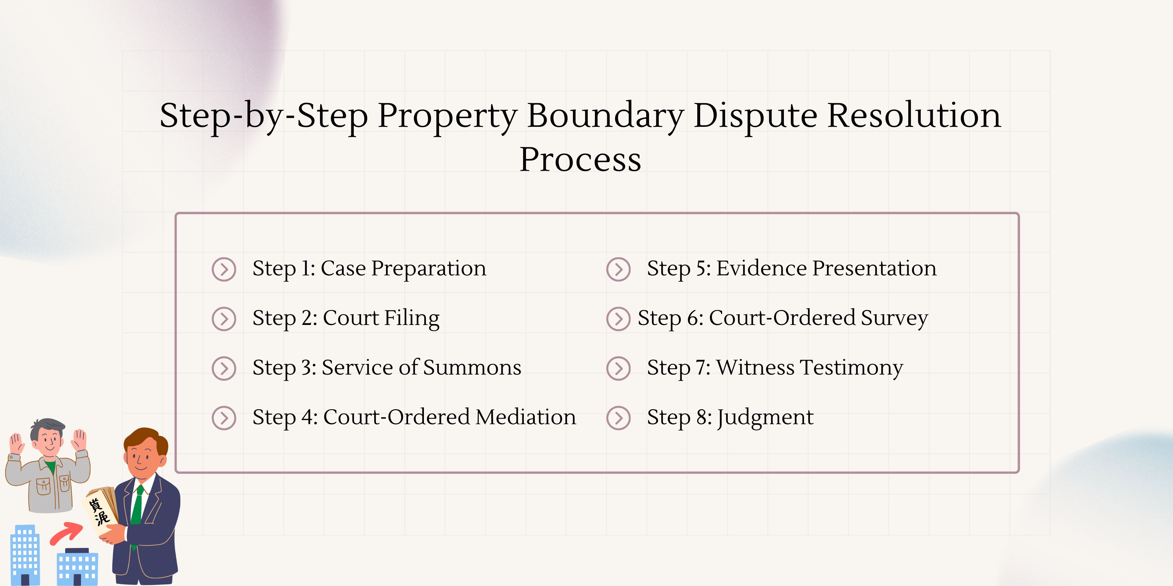
Step 1: Case Preparation
Plaintiff gathers all documents, evidence, and witness testimonies. A plaint is drafted stating claims and relief sought.
Step 2: Court Filing
Case is filed at relevant District Court. Filing fees are paid based on property value (typically NPR 5,000-25,000). Supporting documents are submitted.
Step 3: Service of Summons
Court issues summons to defendant. Defendant has 15-30 days to file written reply.
Step 4: Court-Ordered Mediation
Per Civil Procedure Code Sections 193-195, mandatory mediation is attempted. Parties receive 30 days to settle. If successful, settlement is court-approved. If unsuccessful, litigation proceeds.
Step 5: Evidence Presentation
Documentary evidence includes:
- Land ownership certificates (Lalpurja)
- Survey certificates and maps
- Historical purchase/gift deeds
- Tax payment receipts
- Photographs and witness affidavits
Step 6: Court-Ordered Survey
Judges frequently order official surveys. Court-appointed surveyors examine property and submit reports. Surveyors may testify regarding methodology.
Step 7: Witness Testimony
Witnesses testify under oath. Neighbors and long-term residents provide valuable historical evidence.
Step 8: Judgment
Court issues binding judgment determining boundary location. Judgments can be appealed within 70 days to Appellate Court, then to Supreme Court.
Evidence Standard: Plaintiffs must prove claims "on balance of probabilities." Evidence must be more convincing than defendant's position.
Comparison of Property Boundary Dispute Resolution Methods
|
Method |
Timeline |
Cost (NPR) |
Success Rate |
Relationship Impact |
Enforceability |
|
Direct Negotiation |
1-2 weeks |
0-10,000 |
40% |
Excellent |
Low |
|
Community Mediation |
2-4 weeks |
0-5,000 |
60% |
Good |
Low |
|
Administrative Resolution |
2-6 months |
5,000-60,000 |
65% |
Fair |
Medium |
|
Professional Mediation |
1-3 months |
5,000-50,000 |
75% |
Good |
High (if court-approved) |
|
Court Litigation |
6-24+ months |
200,000-800,000+ |
85% |
Poor |
Very High |
This comparison helps property owners select appropriate property boundary dispute legal solution pathways.
Required Documentation for Property Boundary Disputes
Comprehensive documentation strengthens any property boundary dispute legal solution case. Courts and administrative bodies require specific documents.
|
Document |
Purpose |
Obtaining Authority |
Importance Level |
|
Land Ownership Certificate (Lalpurja) |
Proves legal ownership |
Land Revenue Office |
Essential |
|
Survey Map |
Shows exact boundaries |
Survey Department |
Essential |
|
Tax Payment Receipts |
Confirms current obligations |
Land Revenue Office |
High |
|
Citizenship Certificate |
Verifies identity |
District Administration Office |
High |
|
Property Purchase/Gift Deed |
Establishes acquisition history |
Relevant registration office |
High |
|
Witness Statements |
Supports claim evidence |
Self-prepared with notary |
Medium |
|
Photographs of Boundaries |
Visual evidence of current state |
Self-prepared |
Medium |
|
Previous Court Decrees |
Shows prior legal determinations |
Court archives |
Medium |
|
Municipal Maps |
Alternate boundary reference |
Local municipality |
Low |
All documents should be original or certified copies. Photocopies are typically not accepted in court proceedings.
Cost Structure and Timeline Analysis for Property Boundary Dispute Legal Solution
Direct Costs by Resolution Stage
Pre-Litigation Expenses:
- Document verification: NPR 500-2,000
- Initial survey: NPR 2,000-10,000
- Lawyer consultation: NPR 500-2,000 per hour
Mediation Costs:
- Court-appointed mediator: Free
- Private mediator: NPR 5,000-20,000
- Venue and administrative: NPR 1,000-5,000
Court Litigation Expenses:
- Filing fees: NPR 5,000-25,000 (value-based)
- Lawyer fees: NPR 100,000-500,000+ (case complexity)
- Court-ordered survey: NPR 10,000-100,000
- Expert witness fees: NPR 5,000-15,000
- Miscellaneous: NPR 10,000-30,000
Total Investment: NPR 200,000-800,000+ for full litigation. Administrative resolution costs NPR 5,000-60,000. Mediation ranges from NPR 5,000-50,000.
Timeline Expectations
Administrative Resolution:
- Document gathering: 1-2 weeks
- Land Revenue Office processing: 2-4 weeks
- Official survey (if required): 4-8 weeks
- Total: 2-6 months
Court Litigation:
- Case filing to first hearing: 2-4 weeks
- Mediation period: 30 days mandatory
- Evidence collection: 2-6 months
- Witness testimony: 1-3 months
- Judgment: 1-3 months
- Total: 6-24 months (complex cases may exceed 3 years)
Expedited Options:
- Interim orders can be sought within 2-4 weeks if immediate relief is needed
- Summary procedures available for clear-cut cases
Early intervention significantly reduces both costs and resolution time. Property boundary dispute legal solution should be pursued promptly when issues arise.
Prevention Strategies for Future Boundary Disputes
Preventive measures are more cost-effective than dispute resolution. Property owners should implement these practices:
Regular Professional Surveys: Properties should be surveyed every 5-10 years. Professional surveys establish clear, documented boundaries. Survey certificates should be stored safely.
Permanent Boundary Markers: Concrete pillars should be installed at all corners. Markers should be photographed with GPS coordinates. Maintenance schedules should be established.
Written Boundary Agreements: Neighbors should sign written agreements acknowledging boundaries. Agreements should be notarized and registered. Updates should be made when changes occur.
Clear Documentation: All property documents should be organized and copied. Digital backups should be stored securely. Tax payments must be kept current.
Pre-Construction Verification: Before any construction, boundaries should be verified. Neighbor consent should be obtained in writing. Building permits should specify exact locations.
Insurance Coverage: Property boundary dispute insurance is available in some areas. Legal protection policies may cover dispute resolution costs. Coverage details should be reviewed annually.
Proactive boundary management prevents most disputes. Property boundary dispute legal solution is most effective when prevention fails.
When to Seek Professional Legal Assistance for Property Boundary Dispute Legal Solution
Certain situations require immediate lawyer involvement:
Complex Inheritance Cases: Multiple heirs with competing claims need expert guidance. Legal interpretation of ancestral property rights is required. Partition deeds must be properly drafted and registered.
High-Value Properties: When property value exceeds NPR 5,000,000, legal costs are justified. Financial stakes warrant professional representation. Mistakes can be extremely expensive.
Active Encroachment: When structures are being built on disputed land, urgent legal action is needed. Interim injunctions may be necessary. Delays cause irreversible harm.
Government or Institutional Involvement: Disputes involving public land or government entities require specialized expertise. Different procedural rules apply. Experienced counsel is essential.
Cross-Boundary Issues: When disputing parties live in different districts, jurisdictional complexities arise. Multiple legal systems may be involved. Professional navigation is critical.
Emotional Distress: If dispute causes significant stress, anxiety, or family tension, lawyers provide objective distance. Legal professionals handle conflict while clients focus on well-being.
Failed Negotiations: When direct talks have broken down, lawyers can reopen communication channels. Formal legal processes may be the only remaining path.
Most property boundary dispute legal solution cases benefit from initial legal consultation, even if full representation isn't required. Early advice prevents costly mistakes.
Frequently Asked Questions about Property Boundary Dispute Legal Solution
1. What is the first step in resolving a property boundary dispute in Nepal?
The first step is gathering all relevant documents, including the Land Ownership Certificate (Lalpurja), survey map, and tax receipts. Direct negotiation with the neighbor should then be attempted. If this fails, administrative resolution through the Land Revenue Office is recommended.
2. How long does property boundary dispute resolution take in Nepal?
Direct negotiation may resolve issues in 1-2 weeks. Administrative resolution typically takes 2-6 months. Court litigation usually requires 6-24 months. Complex cases may extend beyond 3 years.
3. What documents are essential for property boundary dispute legal solution?
Essential documents include the Land Ownership Certificate (Lalpurja), survey map from the Survey Department, current tax payment receipts, citizenship certificate, and any historical purchase or gift deeds. Witness statements add strength to claims.
4. Is a private survey acceptable in court for boundary disputes?
Private surveys can be submitted as evidence, but official government surveys carry significantly more weight. Courts give heavy authority to Survey Department findings. Private surveys are best used for negotiation purposes before filing court cases.
5. Can property boundary disputes be resolved without going to court in Nepal?
Yes, many disputes are resolved through direct negotiation, community mediation, or administrative processes. Approximately 60-75% of cases are settled before reaching final judgment. Court litigation is the final resort when other methods fail.
6. What are the costs involved in property boundary dispute legal solution?
Costs range from minimal for direct negotiation to NPR 5,000-60,000 for administrative resolution. Court litigation typically costs NPR 200,000-800,000+, depending on complexity and duration. Mediation offers middle-ground costs of NPR 5,000-50,000.
7. What is the role of the Survey Department in boundary disputes?
The Survey Department conducts official land measurements. Their surveys are considered authoritative evidence in court. The department issues certificates that establish official boundaries. These surveys are registered with Land Revenue Offices.
8. How effective is mediation for property boundary disputes in Nepal?
Mediation has a 60-75% success rate for boundary disputes. Community mediation through ward offices is free and culturally appropriate. Professional mediation offers structured negotiation with neutral facilitators. Court-annexed mediation becomes enforceable when approved by judges.
9. What happens if a neighbor refuses to acknowledge an official survey?
Official survey results can be challenged in court, but the burden of proof lies with the challenging party. Courts accept official surveys unless clear contradictory evidence is presented. Continued refusal to comply after court judgment may result in contempt of court charges.
10. Are there time limits for filing property boundary dispute cases?
Yes, general property disputes must be filed within six months of the unlawful action. However, partition cases have a three-month limitation period. Specific circumstances may affect these timelines, so prompt legal consultation is advised.
Conclusion: Effective Property Boundary Dispute Legal Solution in Nepal
Property boundary disputes require systematic approaches for resolution. The property boundary dispute legal solution framework in Nepal offers multiple pathways from informal negotiation to court litigation. Success depends on selecting appropriate methods based on dispute complexity, relationship importance, and financial considerations.
Preventive measures remain the most cost-effective strategy. Regular surveys, clear documentation, and neighbor communication prevent most disputes. When conflicts arise, early intervention through mediation or administrative channels often succeeds.
Understanding legal rights under Muluki Civil Code 2074 empowers property owners. Collaboration with experienced legal professionals ensures informed decisions. While court litigation provides definitive resolution, alternative methods preserve relationships and reduce costs.
The evolving digitalization of land records promises fewer future disputes. However, current property owners must navigate existing systems skillfully. This guide provides the knowledge needed for effective property boundary dispute legal solution in Nepal.
Call to Action: Secure Your Property Rights Today
Don't let boundary disputes threaten your property investment. Professional legal assistance is available throughout Nepal. Experienced property lawyers can evaluate your situation, recommend optimal strategies, and guide you through resolution processes.
Contact a qualified property attorney today for a confidential consultation. Early legal intervention saves time, money, and stress. Your property rights deserve protection through proper property boundary dispute legal solution.
References
National Legal Frameworks:
- Nepal Law Commission - Muluki Civil Code 2074
- Department of Land Management and Archives - Land Act and Regulations
- Survey Department - Land Survey and Measurement Act 2019
Supreme Court Precedents:
- Premprasad Timsina and others Vs. Ramananda Timsina (NKP 2075, D.N. 10035) - Partition deed registration requirements
- Manoharlal Agrawal Vs. Bhagawandas Agrawal (NKP 2080, D.N. 11138) - Private acquisition vs. common property
Government Resources:
International Best Practices:
- LSE Research - Land Dispute Settlement Mechanisms in Nepal
- World Bank - Land Administration in Nepal
Professional Legal Services:
These authoritative sources provide additional depth on property boundary dispute legal solution frameworks. Regular consultation of updated legal resources is recommended, as land laws evolve.
Contact and Consult Nepal Lawyer Service for Property Related disputes our top lawyers are always here in your service. Call at- +977- 9801884499